
 |
| Brooke Hansen, Jack Rossen, Tyler DeMonde, Jonathan Rodriguez, Adam Sax, Elliot Alvarez, Timothy Lomberk, Julia Evo, Amy Gatenbee, Laura Harrison, David Scheidecker, Kiana Sladicki, Trinity Miller, Bonnie Lee, Cassie McCabe (me), Kara Cook |
In May of 2019 I participated in a project on Egmont Key, in conjunction with USF (Patel College of Global Sustainability and Access 3D Lab), the Egmont Key Alliance and the Seminole Tribal Historic Preservation Office (THPO). Egmont Key, which has been dubbed "the Incredible Shrinking Island," has lost half of its land mass over the last 100 years. The power plant which was originally built in the middle of the island in 1919, is now a popular snorkeling destination.

This project aims to digitally capture remaining historical structures on the island, before total submersion, allowing future generations to explore this small but historically significant island. Also this project hopes to shed light on the lesser known Seminole internment that occurred here due to the Indian Removal Act of 1830. Egmont Key was used as a holding area for Native Americans taken from south Florida to Oklahoma in 1858-9.


Dr. Brooke Hansen and Dr. Laura Harrison envisioned this project and brought it to fruition and to them we are all very thankful.
We started this project learning how to use terrestrial LiDAR scanners. Terrestrial
laser scanning (TLS) or Terrestrial LiDAR (light detection and ranging)
collects 3D coordinates by firing laser pulses at a target and measuring the return
distance to the scanner. TSL scanners can capture up to a million points per
seconds with millimeter accuracy. The points create a photo-realistic point cloud dataset which
can be converted into a DEM (digital elevation model). DEMs can be used for topographic
mapping and spatial analyses. Practical uses include creating high-resolution
survey grade maps of sites and 3D mapping.
 |
| Me and Brooke |
Dr. Laura Harrison from USF’s Access 3D Lab was our project coordinator. We used
the FARO Focuss 150, which has a
150m range.

Our initial scan site was the Battery Charles Mellon (1898). The Mellon Battery was built during the Endicot Perdiod as part of Harbor Defense of Tampa Bay. The battery was decommissioned during the 1920 disarmament program.


Dr. Mel Rogers introducing Photogrammetry
Animation I made from the drone point cloud on Pix4Dmapper Pro
 |
| ArcGIS Polygons 2013 & 2015 |
DEMs 2007 & 2013


Animation I made on ArcScene
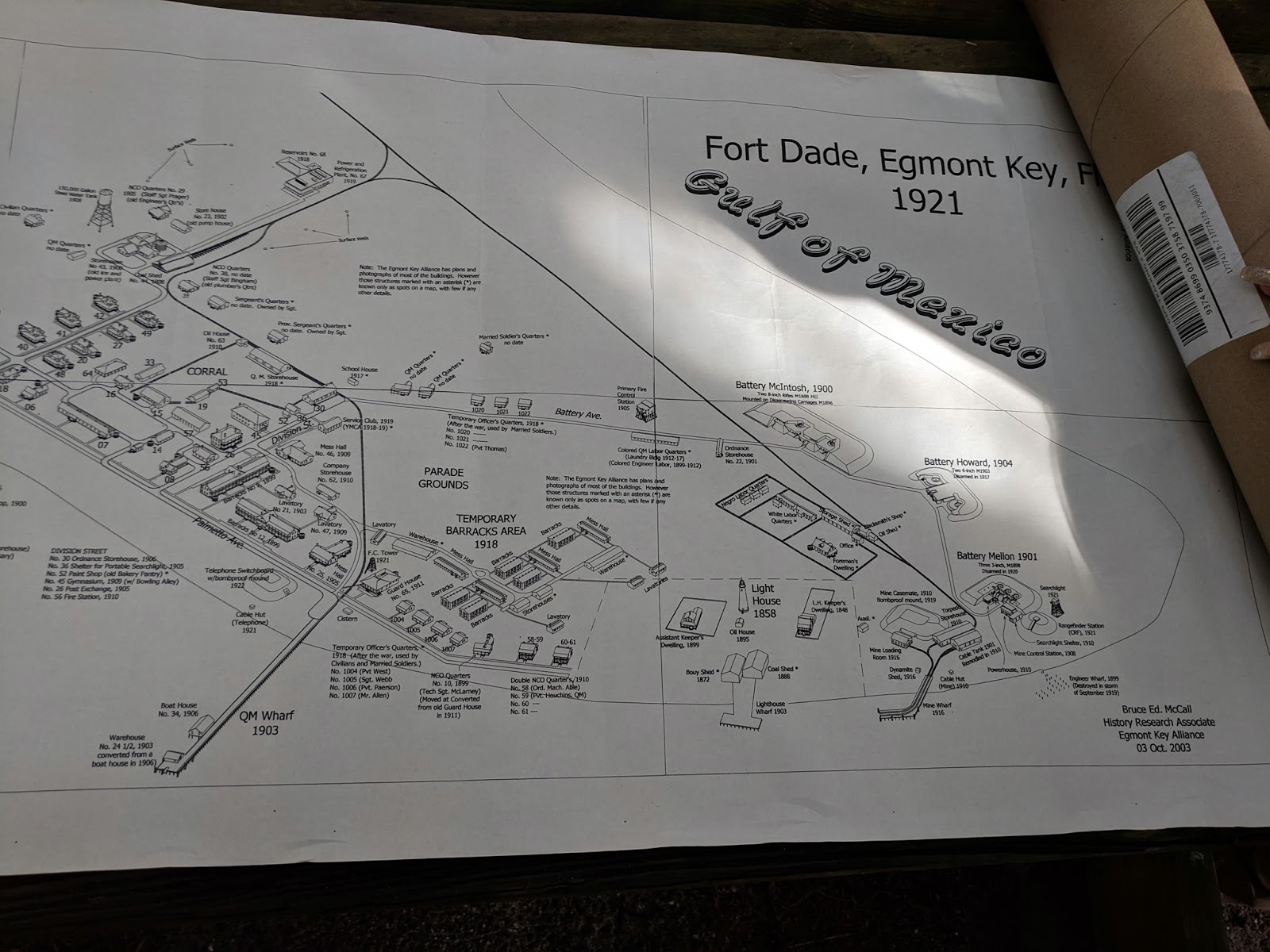
Richard Sanchez, the President of the Egmont Key Alliance was actively involved in our project. He gave us a personal tour and contributed a variety of historical knowledge about the island. We explored the island's "ghost town," which consists mostly of surprisingly intact brick roads with some not so solid foundations, where there was once tennis courts, a hospital, a post office and many other city dwellings, including the morgue. Fort Dade was built during the Spanish American War of 1898, however by the time the structures were built three years later, the short-lived war was long over.

Some highlights from his presentation:
- Clara Barton was a Red Cross nurse on the island when soldiers were quarantined due to yellow fever during the Spanish American War.
- Robert E. Lee suggested preserving Egmont Key for military purposes while he was there, however he was only a junior officer at the time.
- Egmont Key is an archaeological preservation worst case scenario: erosion, humidity, fires, inundation from water, and development of Fort Dade during a time with no historical preservation laws whatsoever; therefore they must rely on oral history and archives.
- Analyzing human remains is strictly taboo for the Seminoles as they don’t touch dead bodies (even dead animals other than for food). When burials are found, all work stops.
- Egmont Key was decommissioned by the military in 1923, the Coast Guard was there until 1974, and Egmont Alliance came out in 1989. It is unclear what happened in between.
- The Cemetery was dug up in 1909-1912 and the soldiers and 5 or 6 unknown Indians were sent to St. Augustine National Cemetery, where there are many other burials from the “Indian Wars.” Civilians were given to their families wherever possible.
- The helipad is the assumed location of the Indian depot because it is naturally open and flat, as well as located near the lighthouse and the former docks. The blockhouse style was two levels with wooden palisade walls, and was the standard defense building against Indians.
- Polly Parker was a tribal member who was captured on the last ship on the way to Oklahoma. They stopped at St. Marks and she convinced the guards to let them out to collect medicine, where half of them escaped. They walked back from Tallahassee to Okeechobee. She was very sick, however survived to over 100 years old. She went on to mother several more children in her late thirties and beyond (last known daughter birthed at 51), with approximately 20% of the Brighton reservation of Seminole being descendant from her.
- The Egmont Key Indian depot was built and used in 1857 and left in 1858. It was not standard military procedure to burn down at that time. Soldiers from the Civil War would have appeared as early as 1861, followed by soldiers from WWI. It is unclear/unknown what exactly happened to the remains, and since they were wooden, any evidence is likely lost.
They can’t turn back waves, but USF and Seminoles are preserving Egmont Key in digital form.
IN THE FIELD
Date:
|
Location:
|
Scanner Type:
|
Scanner Name:
|
Team Members:
|
Scan
Positions:
|
Amount of Data
Collected:
|
5/6/2019
|
Mellon
Battery
|
FARO Focus S150
|
Chorizo
|
Tyler DeMonde,
Trinity Miller, Cassie McCabe, Kiana Sladicki
|
7
|
1.32 GB
|
5/7/2019
|
Mellon
Battery
|
FARO Focus S150
|
Chorizo
|
Tyler DeMonde,
Trinity Miller, Cassie McCabe, Kiana Sladicki
|
12
|
1.61 GB
|
5/8/2019
|
Mellon
Battery
|
FARO Focus S150
|
Chorizo
|
Tyler DeMonde,
Trinity Miller, Cassie McCabe, Kiana Sladicki
|
7
|
1.37 GB
|
5/9/2019
|
Mellon
Battery
|
FARO Focus S150
|
Chorizo
|
Tyler DeMonde,
Trinity Miller, Cassie McCabe, Kiana Sladicki
|
10
|
1.98 GB
|
5/10/2019
|
Mellon
Battery
|
FARO Focus S150
|
Chorizo
|
Cassie McCabe,
Kiana Sladicki
|
5
|
1.03 GB
|
5/15/2019
|
Lighthouse
|
FARO Focus S150
|
Chorizo
|
Tyler DeMonde,
Trinity Miller, Cassie McCabe, Kiana Sladicki
|
10
|
2.13 GB
|
5/16/2019
|
Lighthouse
|
FARO Focus S150
|
Chorizo
|
Tyler DeMonde,
Trinity Miller, Cassie McCabe, Kiana Sladicki
|
10
|
1.77 GB
|
5/17/2019
|
Lighthouse
|
FARO Focus S150
|
Chorizo
|
Tyler DeMonde,
Cassie McCabe, Kiana Sladicki
|
9
|
1.60 GB
|
5/23/2019
|
Lighthouse/Cemetery
|
FARO Focus S150
|
Chorizo
|
Cassie McCabe,
Kiana Sladicki
|
2.01 GB
|
|
5/24/2019
|
Cemetery
|
FARO Focus S150
|
Chorizo
|
Cassie McCabe,
Kiana Sladicki
|
1.10 GB
|
May 6th, Day 1: Intro to Scanning with Dr. Laura Harrison
Dr. Harrison's Scan Plan for Day 1
Today we learned about sphere placement:
- Minimum 2 spheres, ideally 3-5
- Scan 3 permanent every day
- Don't place in a line
- Make sure the scanner isn't
splitting a sphere
We
positioned our three permanent spheres that will be used for the duration of
the scan at this site. We must scan the 3 permanent spheres every day for “geo-referencing,”
which is possible without spheres, but much more difficult. Vegetation/metallic/shiny/black/highly
textured surfaces are more difficult to scan. We must scan directly under
doorways. We
discussed our preliminary scan plan with advice from Laura. We started the scan
and exited the scan area, to minimize the disruptions in the scan
cloud/photos. We learned how to set up the
scanner:
Important Scanner Settings:
Project
Setup:
Manage -> Projects
-> Default Project -> “+”
Project Name:
Egmont_Chorizo
File Base Name:
Egmont_Chorizo_0506_CM_
o Notice the file base name has an underscore after the
word!
Initial Scan No:
1 (from 0)
Profile Setup:
Manage -> Profiles -> Outdoor
greater than 20m “20m…”
Parameters -> Resolutions -> ¼
Resolution, 4X Quality
Parameters -> Color
Settings -> Exposure Metering: Even Weighted
Scan
Duration: 10:16
Manage -> Sensors -> Inclinometer:
Make sure the Inclinometer is centered in the blue.
 |
| Me, Tyler DeMonde, Trinity Miller, Kiana Sladicki, and Chorizo (Scanner) |

Today we
developed our own scan plan. Scan 7 was deleted due to interference in the field.
We went on a tour of the island with Richard Sanchez from the Egmont
Alliance.
Some
scanning notes:
Inclinometer
is difficult on the sand, kept sinking -> yellow
We had a
dead battery at the start
The 10:16
scan time is NOT accurate, closer to 12:30 (perhaps the 2 extra minutes is for
the photos?)
Some
notes about Egmont key/the project:
It is a
popular tourist destination with many tourists walking through (will be in
scans)
Our
scanner is about 50ft from the water, with 6” of SLR, the fort will be
underwater
People
are taking bags of shells from beach, in fact the ferry was selling shell bags
and encouraging visitors to take as many as they can carry, despite there being
signs forbidding removal of any artifacts
Ferry
also chases dolphins and other wildlife, which goes against Sustainable Tourism
best practices
 |
| Taking a break from the sun! |

May 8th,
Day 3: Drone Day with Dr. Mel Rogers
We
continued scanning the Mellon battery. Environmental challenge: love bugs! Scan
3 was deleted because of scanner error ("scan incomplete").
Today,
Kiana and I worked with Dr. Mel Brooks and her drone to collect photogrammetry
data from the helipad.

 |
| Kiana Sladicki, Dr. Mel Rogers and me on the helipad, the supposed site of the Indian depot |

May 9th, Day
4: Tour from Dave
Scheidecker
Today Dave Scheidecker, a representative of the Seminole Tribal Historic Preservation Office, came out with us and gave us a great history of the island.
Today Dave Scheidecker, a representative of the Seminole Tribal Historic Preservation Office, came out with us and gave us a great history of the island.

Today we
learned about stitching everything together as we moved from one side of the
battery to the opposite to get the outside wall. We finished early because of
the scan plan.


Today we were in the Access 3D lab. We used FARO Scene to look at the scan data from day
one. We learned how to clean up the data by removing unwanted objects such as
people, tripods, scanners, cases, and spheres.
Tyler DeMonde's video
1. Transfer your ALL data from SD
cards to your desktop
a. Don’t just import the
scans. You need to keep the Backup, Preview, Projects, and Scans together. The
data is all connected. If you separate them at this beginning stage you will
have issues later on.
b. Organization is key!
Divide data by day and then by scanner.
c. Example:
12-17-2018
Chorizo
Manchego
Diego
12-18-2018
Chorizo
Manchego
Diego
2. When in Scene click CREATE
PROJECT and name your project. Pick your save location.
a. Easiest to keep a designated
save location for all your Scene projects.
3. Go to the IMPORT tab and drag
in scan data.
a. In this stage, you just
need the scan data.
b. When it has imported you
need to press OK, otherwise it will not let you import anything further.
4. Once you have imported all
your scans save your project in the save tab.
a. Add what step you’re on in
the comments section just in case you have to revert back.
5. Go to the PROCESSING tab and
press process, on the upper right-hand corner of the screen.
a. Check:
i. Dark
Scan Point Filter
ii. Stray
Point Filter
iii. Find
Spheres
b. Start processing
6. Once processed save and then
subdivide by day and scanners (will make your life so much easier).
7. Go to the REGISTRATION tab.
Pick a section from a day and press AUTOMATIC registration first by targets.
a. If it fails to register
automatically by targets then try automatic registration by top down view and cloud
to cloud.
b. If this doesn’t work go
into MANUAL registration and manually pick spheres or points in planar view.
i.
Be sure to save often and write comments. You will inevitably have to revert to
a previous save and it helps to have
your notes.
8. Go to the EXPLORE tab and
create a Project Point Cloud (PPC).
a. Check:
i. Eliminate
duplicate scan points
ii. Homogenize
point density
iii. Apply
color balancing
9. Clean scan data by using the
clipping box and lasso selection.
a. Save frequently and update
the PPC every hour at least.
Next up to scan was the lighthouse. We started with all three scanners doing a loop around the lighthouse, with both an inner and outer track. Then as the other two scanners moved around the other buildings, Chorizo went inside the lighthouse. Due to the symmetry of the lighthouse, I suggested we add a letter suffix to each File base name to make stitching it together easier in the lab (i.e. Egmont_Chorizo_20190516_CM_A_). We were able to open the windows of the lighthouse, which allowed us to capture outside spheres in the bottom scans. Things got a little tight in the lighthouse, so Kiana and I tackled most of the inside on our own. We found it best to use the spheres with the stronger magnets, since most of our sphere placements tended to be on the stairwell/other metal structures. We were able to leave spheres inside over night, to serve as permanents so we could get going quickly everyday.


May 20th, 21st, & 22nd, Day 11-13: In the Lab with Steven Fernandez
We went back to the Access 3D lab, this time to work with Steve Fernandez. For me, this was the most challenging aspect of the project, as I am basically computer illiterate! There were a few hiccups, mainly the computers malfunctioning, but we were able to complete several projects from previous data on the island (NOAA), and our point clouds from the scanners and drones.
 |
| Jon Rodriguez' DEM |
Returning to the lighthouse after 5 days, we entered into a bit of a disaster. Two of the four spheres we left in place had fallen (magnets attached to the stairwell). We still had two left to stitch together and during our scanner setup, one of them was knocked over, leaving us with only one! Luckily we were in a window portion of the lighthouse, with multiple geometric points allowing for manual stitching in the lab. After we finished up the lighthouse, we joined the other two scanners in the cemetery. We did a loop around the cemetery as the others did inside. Note: we did not want to put any stakes into the cemetery for permanent spheres, out of respect for the dead.
We wrapped up our scanning for the project and enjoyed a great BBQ. We were awarded our Gold Badges for the project.


Read other articles about Egmont Key here:
Seminole Tribe searches for remains of ancestors on Egmont Key
Seminole Indians and Egmont Key
An Island Fortress: Egmont Key's Fort Dade
Heritage Washing Away
My group partner, Trinity Miller, made this incredible story map!


 |
| Go Bulls! |


Living The Green Dream: Preserving The Incredible Shrinking Island: Lidar, Sfm, And Gis On Egmont Key, Fl >>>>> Download Now
ReplyDelete>>>>> Download Full
Living The Green Dream: Preserving The Incredible Shrinking Island: Lidar, Sfm, And Gis On Egmont Key, Fl >>>>> Download LINK
>>>>> Download Now
Living The Green Dream: Preserving The Incredible Shrinking Island: Lidar, Sfm, And Gis On Egmont Key, Fl >>>>> Download Full
>>>>> Download LINK